Britain has an incredible richness and diversity of cities, and since the turn of the century there has been significant urban revival and renewal. Yet there are also persistent urban problems in the UK that are proving very difficult to solve. Understanding and comparing social and economic trends can play an important role in identifying where cities are succeeding and failing, sharing best practice, and assessing where policy changes are needed.
This is the approach we’ve taken with LuminoCity3D, a new interactive city mapping platform which allows intuitive visual comparisons between cities across a wide range of indicators, providing insights into patterns and dynamics. These indicators are mapped using a new 3D grid-based approach which allows consistent comparisons between urban areas.
All the datasets have been transformed to a 1km2 hexagon grid, providing a standardised spatial framework for the whole of Britain. Each grid cell is also displayed as a 3D block – with heights representing population or employment density. The transformation depends on the availability of high resolution data, which is available for urban areas. However in rural areas where populations are sparser and census zones larger this approach is not suitable, so villages and rural areas are not included in the visualisation
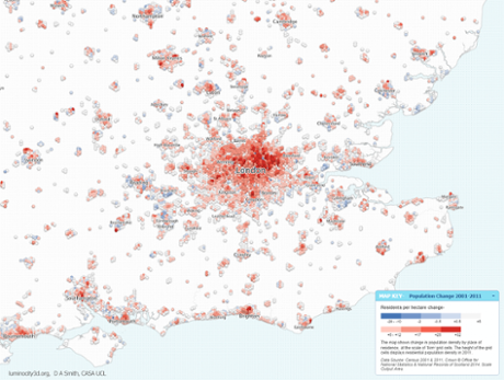
The main positive trend for British cities is one of significant growth. London gained one million residents between 2001 and 2011, and this growth has spilled across the south-east. The fastest growth in percentage terms has been in medium-sized settlements such as Milton Keynes (20%), Ipswich (15%), and Cambridge (16%) - see the image at the top of the article.
This growth is by no means confined to the south-east. Greater Manchester gained 200,000 residents, Birmingham and the West Midlands 160,000 and Leeds and West Yorkshire 120,000 between 2001 and 2011. Growth is primarily in densifying city centres, and is strongly connected to employment change, as the map above shows.
Growth industries, such as business services, ICT and creative industries are increasingly attracted to vibrant high-density centres. Northern cities are competing to attract these knowledge economy sectors and the hierarchy of urban business centres is evolving, with larger cities taking the lead.
The revival of city centres also has important travel sustainability consequences. Higher urban densities can support public transport systems, and encourage walking and cycling.
But public transport requires substantial planning and investment, and there are startling inequalities in infrastructure across the UK. London can boast nearly 50% commuting by public transport, compared to Greater Manchester and the West Midlands which barely manage 15%, and Merseyside and Tyne and Wear at 20%.
While building a London-style underground system in every city is clearly unrealistic, much can be achieved with more modest investment. Edinburgh for example has achieved 35% public transport commuting through a well-planned and publicly owned bus network.
The north-south divide is still very much in evidence in the UK, with the south-east outperforming other regions in most socio-economic indicators, from occupational class to education. But soaring demand combined with a chronic lack of new housing has created an unprecedented affordability crisis in the south-east, with London now among the most expensive cities in the world. Median house prices in 2013 were nearly £300,000, with the some areas well above £1m. These extreme prices increasingly extend beyond London to many cities in the region.
The reason why London and surrounding cities are so closely connected, and indeed why Leeds and Bradford or Newcastle and Sunderland are, is the regional nature of cities. Regional connections can be visualised by plotting flows between home and work locations.
The reach of London is staggering with flows stretching 100 kilometres or more, while connections between cities in the Midlands, North-West and North-East are clearly highlighted. Long distance flows to central London reflect the quality of jobs and the lack of affordable housing nearby, putting a strain on transport networks and commuters lifestyles.
Other city regions in contrast could benefit from improved connections. The lack of interaction between nearby Manchester and Leeds for example reflects poor transport infrastructure.
Ultimately the regional approach is a much needed perspective for understanding city trends, and should be more strongly reflected in how we approach city planning and policy.
The visualisation style in LuminoCity3D has some differences to standard maps. Density is of primary interest in sustainable cities research, as it connects a host of socio-economic patterns. Therefore density is directly mapped in LuminoCity3D as the height of zones (either as population density for resident-based indicators or employment density for workplace indicators) in the manner of a 3D cartogram. This approach clearly communicates the size of urban centres and how urban form relates to the various socio-economic indicators.
Additionally all the data has been converted to a standardised grid of cells, each 1 square kilometre in size. This grid technique is used because density measures are very sensitive to zone size. The grid provides a consistent framework for the comparison of all urban areas across Great Britain.

